Kamil impact crater in Egypt
AC
Sparavigna, Politecnico Torino
An
impact perfectly preserved crater is the Kamil
crater, discovered
during a survey of
satellite images on Google Earth. Researchers think the crater as formed within
the past thousand years (it is estimated to be less than 5,000 years old) [1].
Kamil Crater is a
As
the figures are showing, the Kamil crater possesses a
rayed structure. It is estimated to be less than 5,000
years old. The crater was produced by an iron
meteorite, which fragmented in thousands
of pieces after impact with the ground.
Meteorite fragments for a total of
Figure
1 is the crater as it is possible to observe from Google Maps. Figure 2 is the image of the Kamil
Crater obtained after processing image in Fig.1 with AstroFracTool
[2], followed by a Gimp adjustment of contrast and brightness. Note the
enhancement of details of the ground surface. The use of AstroFracTool
is creating an embossment effect. In the Fig.3, after AstroFracTool
processing, the Gimp Curves tool, for changing the
color, brightness, contrast is
applied: note the enhanced visibility of the rayed structure.
Reference
1) L. Folco, M. Di
Martino, A. El Barkooky, M.
D'Orazio, A. Lethy, S. Urbini,. I. Nicolosi,.M.
Hafez, C. Cordier, M. van Ginneken, A. Zeoli, A.M. Radwan, S. El Khrepy, M. El
Gabry, M. Gomaa,.A. A. Barakat, R. Serra, M. El Sharkawi, The Kamil Crater in Egypt, Science, 22 July 2010,
DOI: 10.1126/science.1190990
2) Roberto Marazzato, Amelia
Carolina Sparavigna, Astronomical image processing based on fractional
calculus: the AstroFracTool, 26 Oct 2009, Instrumentation
and Methods for Astrophysics, arXiv:0910.4637v2 [astro-ph.IM],
http://arxiv.org/abs/0910.4637

Fig.1 Kamil Crater as
shown by Google Maps.
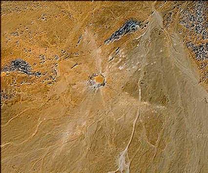
Fig.2 Image of the Kamil Crater obtained after
processing image in Fig.1 with AstroFracTool and
Gimp, to adjust contrast and brightness. Note the enhancement of details.

Fig.3 Image obtained after processing the image in Fig.1 with AstrofracTool and the Gimp Curves
tool, for changing the color, brightness, contrast.
Note the enhanced visibility of the rayed structure.