Symbolic
landforms created by ancient earthworks near Lake Titicaca
- arXiv:1009.2231 - The geoglyphs of
Titicaca
Amelia
Carolina Sparavigna, Politecnico
di Torino
Geoglyphs created in an
ancient network of earthworks are shown, using Google satellite imagery
enhanced by an image processing. This network covers a large part of the land
near the
From: A.C. Sparavigna, Symbolic
landforms created by ancient earthworks near Lake Titicaca, http://arxiv.org/abs/1009.2231, Cited by http://www.technologyreview.com/blog/arxiv/25770/, A.C. Sparavigna,
Geoglyphs of Titicaca as an ancient example of graphic design, http://arxiv4.library.cornell.edu/abs/1009.4602
Notizia in italiano: Redazione Archaeogate, 08-10-2010, Ricercatrice del
Politecnico di Torino individua nuovi geoglifi in Perù elaborando immagini di
Google Maps,
You can find information in Spanish – News
sábado, 09 de octubre de 2010 Geoglifos del Titicaca http://connuestroperu.com/index.php?option=com_content&task=view&id=13147&Itemid=1
viernes, 08 de
octubre de 2010 Titicaca: Descubren gigantescos geoglifos que compiten
con las líneas de Nazca http://connuestroperu.com/index.php?option=com_content&task=view&id=13137&Itemid=1
viernes, 08 de
octubre de 2010 Formas simbólicas de tierra creadas mediante antiguos terraplenes cerca
del lago Titicacahttp://connuestroperu.com/index.php?option=com_content&task=view&id=13136&Itemid=38
Any landform
composed of fine-grained materials evolves in wide and flat relieves, due to
the down-slope transport of its
materials over time. Earthworks, which are artificial landforms, are
subjected to the same destiny, to be
widened and flattened as a consequence of the natural degradation processes [1-3]. These ancient structures remain clearly
visible in the satellite imagery. A wonderful example is a huge network of
earthworks near
The local farmers
acknowledged that these textures are persisting evidences of the remarkable
skills of their ancestors in 1981, when
Clark Erickson,
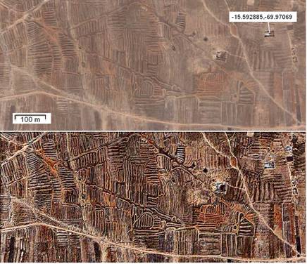 Figure 1: This is a part of the land near
Lake Titicaca (
Figure 1: This is a part of the land near
Lake Titicaca (
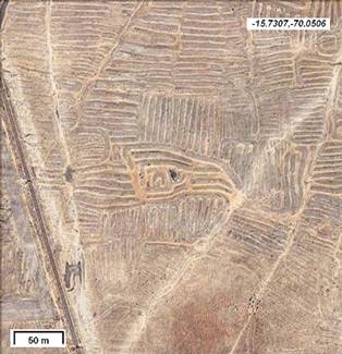 Figure
2: The head of a bird, where the beak is touching an old dry channel.
Coordinates are shown in the figure.
Figure
2: The head of a bird, where the beak is touching an old dry channel.
Coordinates are shown in the figure.
Let us observe the region of
Many other interesting drawings are displayed by the
satellite imagery. Let us see some of them, where their symbolic is quite
evident. They are geoglyphs of huge dimensions.
In Figure 3 we see
a bird, where a circular pond is the eye. In Figure 4, it looks like a condor
being represented on the surface. For the images, a processing method [8] was
used that enhances the edges of earthworks. Two birds can be seen in Fig.5, the
big one is protecting a canal with its beak and claw. In Fig.6, there is an
animal that could be a hedgehog. Another artificial landform that could be a
geo-glyph (a fish or a tortoise) is located at coordinates approx.
-15.6464,-70.132. In Fig.7, a complex scene composed by a snake and an animal
assailing it, covering a huge surface.
Landforms in
Figures 1-7 are in
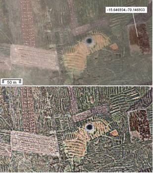 Figure 3: Many interesting drawings are
displayed in the satellite imagery of this land. Among them, there are some
which look as geo-glyphs. Here we see a bird, where a circular pond is the eye.
In the upper panel, the original image from Google, in the lower part the image
enhanced with a previously proposed method [8].
Figure 3: Many interesting drawings are
displayed in the satellite imagery of this land. Among them, there are some
which look as geo-glyphs. Here we see a bird, where a circular pond is the eye.
In the upper panel, the original image from Google, in the lower part the image
enhanced with a previously proposed method [8].
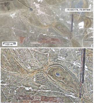 Figure
4. This landform appears as a geo-glyph representing a condor. In the upper
panel, the original image from Google, in the lower part the image, the head
enhanced with a previously proposed method [8].
Figure
4. This landform appears as a geo-glyph representing a condor. In the upper
panel, the original image from Google, in the lower part the image, the head
enhanced with a previously proposed method [8].
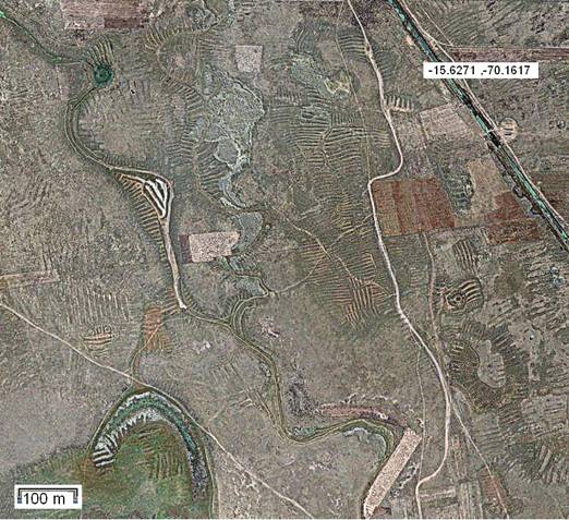 Figure 5: Two geoglyphs in this area. They seem two birds. One is
near the canal with beak and (white)
claw at the bends of it. A green pond is the eye.
Figure 5: Two geoglyphs in this area. They seem two birds. One is
near the canal with beak and (white)
claw at the bends of it. A green pond is the eye.
Another figure is in the lower right part of figure.
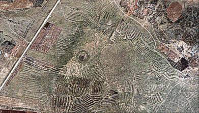
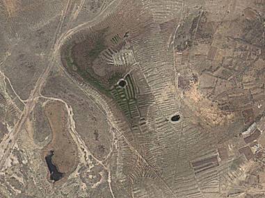
Figure 6: This artificial landform could represent a
hedgehog.
Coordinates of hedgehog are -15.65154,-70.1334 (upside-down).
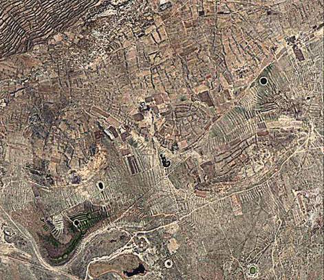 Figure 7: This is a huge geoglyphs. On the
left, a snake with a bifid tongue, on the right an animal assailing it. The
body and skin of the snake are created by the terraced hill, the head (darker
area) is on the plain surface of the ground, a pond as its eye. The
figure is reproducing a region
Figure 7: This is a huge geoglyphs. On the
left, a snake with a bifid tongue, on the right an animal assailing it. The
body and skin of the snake are created by the terraced hill, the head (darker
area) is on the plain surface of the ground, a pond as its eye. The
figure is reproducing a region
A detail of the
head
In Bolivia we see a
large area (approx. coordinates
-16.4275,-68.5822) with raised fields. Here too, we see beautiful
landforms, showing snakes, birds and other objects, not so easy to figure out.
Figure 8 shows a snake and a bird in the Bolivian country. In conclusion, the
paper showed that the previously proposed image processing of natural landforms
[8] can be applied to the study of artificial landforms, such as geo-glyphs.
After processing, having the possibility to observe all the minute details of
structures, a comparison of considered symbolic landforms with those of other
regions is more easy [9,10].
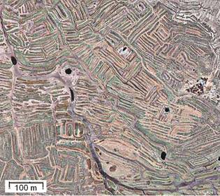 Figure 8: A snake and a bird in a plain
region of
Figure 8: A snake and a bird in a plain
region of
Notes and
references
[1] Being erosion acting
on earthworks, as on all landforms, the
study of those structures with known age
and initial morphology is particularly interesting for
geophysical researches. Comparing the original with the current shape provides
the data for developing and testing models for long-term landform erosion. Such
investigation was applied, for instance, to the Inca agricultural terraces
abandoned at
[2] Pattern and
rate of erosion inferred from Inca agricultural terraces in arid southern
[3] Modeling the
natural degradation of earthworks, M.A. O'Neal, M.E. O'Mansky, J.A. MacGregor,
Geoarchaeology,Volume 20, Issue 7, October 2005, Pages 739–748
[4] Pre-Columbian
earthworks in coastal
[5] Pre-Hispanic
Raised Field Agriculture, C. Erickson, web page, http://www.sas.upenn.edu/~cerickso/
[6] Agricultural
Earthworks on the French Guiana Coast, S. Rostain, The Handbook of
South-American archaeology, Volume 3, 2008, Pages 217-233
[7] Raised field
agriculture in the
[8] Enhancing the Google imagery using a wavelet filter,
A.C. Sparavigna, 8 Sept 2010. Geophysics (physics.geo-ph); Earth and
Planetary Astrophysics (astro-ph.EP), arXiv:1009.1590v1
[9] A
huge literature is available on the subject of geo-glyphs. Let the author note
an article with several images, with a surprising title: Discovery of vast
prehistoric works built by Giants? The Geoglyphs of Teohuanaco, David E.
Flynn, a post of February 24, 2008
[10] http://www.atlantisbolivia.org/geoforms.htm
This site and its contents are subject to
copyright. Amelia Carolina Sparavigna is the owner of copyright. Material - including text and images - on
this site must not be copied or in any other way reproduced without explicit,
prior and written permission.